Wednesday, February 27, 2013

Monday, January 28, 2013
Day Hiking The Big Acorn Nature Trail At Carters Lake
On New Year's Eve this year, we decided to get some exercise in advance of a night of consumption and calories. Carter's Lake was conveniently located near our cabin in Ellijay, so we drove around the 3,200 acre lake and found the visitor's center.

The lady at the counter was very friendly and after our kids named every stuffed animal in the display room, we hit the Big Acorn Nature Trail which starts in the back of the building.

The Trail runs along Carters Lake which is the deepest reservoir lake in Georgia at 450 feet. It's reported to be a popular spot to fish for Walleye - a fish that has eluded me on many trips to Northern Ontario. But back to the hiking .... we only covered about 0.6 miles of the 62 miles of shoreline, yet the Trail was very scenic with winter views of the lake and bright blue water that lit up on this sunny day.


We made our way to a round overlook near the main road which had outstanding views out to Carters Lake.


Then my son and I raced the rest of the group back to the visitors center. In case you are wondering .. the road route is definitely faster.
If you have some time, their is a nice park across the damn with a spillway carved in the side of the mountain. It's worth a look and the kids had fun on the playground while we explored the area.

Overall, I was impressed with Carters Lake. It was very clean and well kept. I'm sure we'll be back - maybe next time to catch some Walleye.
Thursday, December 20, 2012
Long Branch Shelter replaces the old Big Springs Gap Shelter
Out with the old ... and in with the new: The Appalachian Trail Conservancy, Nantahala Hiking Club, and a local company - Goshen Timber Frames - teamed up for the construction of Long Branch Shelter near Glassmine Gap. The new structure is located north of Standing Indian on the Appalachian Trail and about 17 miles from Franklin, N.C.

The new two-story Long Branch Shelter replaces the old Big Springs Gap Shelter (shown below), which was built just north of Albert Mountain.
The Big Springs Gap Shelter is reportedly in a state of disrepair and is scheduled to be dismantled. It is a short walk from a parking area, so the new site for the Long Branch Shelter will offer backpackers more solitude and safety.

The new shelter can also be accessed via Standing Indian Campground where the Long Branch Trail follows Long Branch Creek up 800 feet up to the A.T. at Glassmine Gap. The trail is roughly 2.0 miles long and starts just across the road from the parking area.
Wednesday, May 30, 2012
Lake Winfield Scott Hike To The Appalachian Trail

This is the trailhead for The Jarrard Gap Trail that leads from Lake Winfield Scott to the Appalachain Trail.

The Jarrard Gap Trail starts with a hike through a forest and across a small stream, but quickly hits a forest road for about 0.3 miles.

Boone was enjoying the hike.

After 1.2 miles I reach the Appalachian Trail at Jarrard Gap. I camped here back in 1994 during my thru-hike - so it was cool to see this area again. It looked a lot different with leaves on the trees.
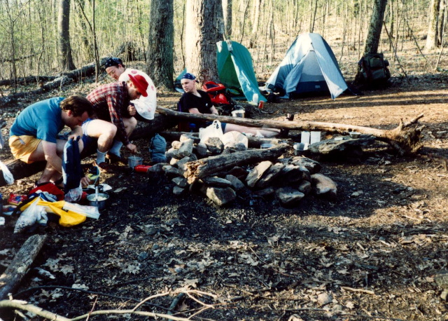

I think my 1994 campsite was in the same spot as this 2012 campsite. The A.T. heads northbound toward Blood Mountain from here (and to the upper right in this photo).

Subscribe to:
Posts (Atom)